So, as I mentioned yesterday, I did take a rather interesting journey. Since it was my last day off before heading back to the world of work, I decided that I really wanted to do something I'd been putting off -- hiking! I scanned the internet trail guides for Connecticut and settled on checking out Breadloaf Mountain, which connects up to the Appalachian Trail and offers views of the Litchfield hills and the Housatonic River valley. The views I figured would be gorgeous, and it was a great day for hiking, but I also just wanted someplace quiet to be with nature, meditate, pray, and maybe read some scripture and/or write. Excited at being in the outdoors once again I took off with gusto, tackling the trail at a fairly aggressive pace. As to be expected - since I haven't done any serious hiking in a while - the moment the trail took its steep, upward climb to the peak, I started to feel the burn in my legs and lungs. But not one to be beaten down easily, I forced my body through the initial pains, drank some water, and continued on. I mean come on, the hike was only 0.5 miles - albeit a lot of it was uphill, severely uphill. After about a half hour of steady climbing I reached the peak and was rewarded with stunning views.
Breadloaf Mountain Looking South 
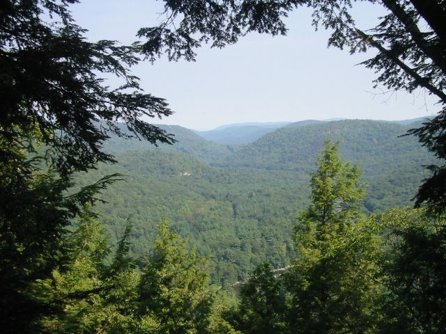
Breadloaf Mountain Looking Across the Housatonic River Valley
I sat for a while taking in the peaceful surroundings, had a snack, and then decided to break out my bible. While at ElderLink, Paul and Jeff had talked about how 2 Corinthians 4 speaks very eloquently about being a missionary - dealing with struggles, keeping focused, and things of that nature. Of course, I'd never really heard that take on it before, but when I sat there during their session thinking about it, it really did speak to me as a kind of comforting, morale booster for someone struggling out in the field. They also talked about how sometimes we need to stop taking everything at face value, the "we heard it once or twice so now we know all there is to know" kind of attitude, and dig deeper from many angles (my words, not theirs). Thinking about all this gave me the reason to tote my bible with me to the top of the mountain. I decided that starting with 2 Corinthians 4 (after a few moments of silent prayer), I was going renew my study of scripture, but with more depth. At first, I read through chapter 4 alone a couple of times, but as I read it I started to realize that it seemed to me there were allusions to something that must have been said previously. So then I decided to skip back a couple of chapters, but as I scanned I realized I really needed to head back to the beginning and read 2 Corinthians 1-4, so I did. I really got a lot more out of that passage of scripture than I ever had before, and I plan on going back and utilizing some of the discussion questions Paul and Jeff provided. So with another moment of prayer, I decided it was time to leave, but seeing as I wasn't tired I figured I would check out another trail I knew was nearby - it was just a short walk along the ridge on the Appalachian Trail to the Pine Knob Loop, which supposedly offered more scenic views. I mean come on, the map shows that they are not that far apart!
Well, first I hiked the 0.1 miles to the Appalachian Trail - no problem - and then headed north to find the Pine Knob Loop. And continued to head north, and more north, and more north. I wasn't really all that tired, the terrain wasn't too steep, so I soldiered on until finally I found the trail. So I headed off figuring that this loop didn't look too long. The trail had a decidedly downward slope to it, nothing terribly difficult just continuous. The loop took me along a really neat stream that at certain points had washed away everything leaving a wide swath of smooth, bare rock and also had some neat ravines.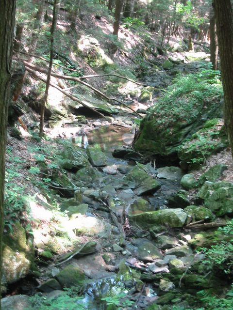
A stream along the Pine Knob Loop
However, as you've probably guessed by now, the trail was not a short jaunt through the woods. I continued down, never curving back up the mountain, and eventually I found myself a mere stones throw from the parking lot (not where my car was) along the main road at the bottom of the mountain. I was a little tired by now and figured I would drink some water and eat the apple I had brought along, and continue on back up the final leg of the loop. I passed a couple with a dog on my way up, and they wished me good hiking and asked why I was taking the steep way up. At this point I was getting a little concerned because I was definitely low on energy and my legs were tired from the not so steep hike down, and decidedly longer than expected hike from Breadloaf Mountain. Nonetheless I continued on, but decided to check the map that I had picked up from the trailhead at the beginning of my journey. That's when I noticed the words -- Map Not to Scale -- Uh oh. I decided that perhaps I should turn around and walk the main road back to my car, since I did know that both parking lots were off the same road. A little further down I passed another guy, he asked how much further up it was to the overlook, he had heard that this was a 3-mile loop but wasn't how far to the scenic view. At this point I knew I had made the right decision to turn around, and so I backtracked to the parking lot, where I found out that by road it was another mile to my car. Once I got back, I went to go get a better look at the topographic map that was there -- as it turns out, the little semi-informational guide that I picked up was completely useless for anything other than pointing out highlights and finding camping and pay-phones. It was 0.6 miles from my car to the Appalachian Trail, probably another 1.5 - 2.0 miles from there to the Pine Knob Loop, I hiked at least half the loop (about 1.5 miles), backtracked about 0.5 mile and lastly walked 1.0 mile back to my car. Grand total estimate for my first hike of the year, and first real outdoors hike in a while -- 5.1 - 5.6 miles over varied terrain. For those of you who like topo maps, check out the terrain from Breadloaf Mtn to the north along the ridge and then the area between the two streams (that's the Pine Knob Loop).
It was an exhausting day, much more than I had planned, but I saw a lot of the beauty of Litchfield County up close. I also felt like I really got in some quality spiritual time, which I also needed. Next time I plan something like this though, I think I'll hit up Barnes & Noble for a guide and map book about Connecticut trails.
Tuesday, September 13, 2005
Subscribe to:
Post Comments (Atom)

1 comments:
Jamie,
Great write up. I enjoyed it, and the photos too. Thanks.
I've meant to get up to that part of the state more often. Kent Falls is about all I've done so far. (It wasn't as big as I thought it would be).
I liked the reflections on Elderlink too.
Post a Comment